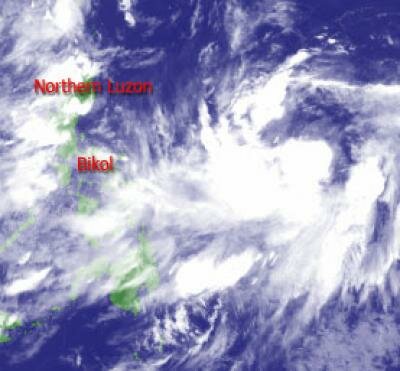
No expected Philippine landfall for Tropical Storm 'Kabayan'

NAGA CITY Philippines (July 29, 2011 8:00 P.M.) - Tropical Storm 'Kabayan' (International name: Muifa) is not expected to hit land anywhere in the country as it moves Northerly towards the Northern Philippine Sea at 13 kilometers per hour (kph).
At 6:00 P.M. today, the eye of the tropical storm was located 1060 kilometers East of Virac, Catanduanes at coordinates 13.9º North Latitude 134.0º East Longitude with sustained winds of 95 kph near the center and gusts up to 120 kph.
With a diameter of 895 kilometers, 'Kabayan' shall remain at sea, traveling no closer than 1000 kilometers off the Eastern coasts of Luzon.
However, 'Kabayan' is expected to continue intensifying over the Northern Philippine Sea at a normal rate and will move on an "S-Shaped" Northward track within the next 24 to 48 hours.
Early tomorrow morning (Saturday), it shall be 1280 kilometers East of Infanta, Quezon as it moves on a slow Northerly to North-Northwesterly track and intensifying to 100 kph.
Tomorrow afternoon, 'Kabayan' nearing typhoon strength at 110 kph shall be 1280 kilometers East of Casiguran, Aurora.
On Sunday morning, it shall become a category 1 Typhoon with sustained wind of 120 kph as it travels 1160 km East of Palanan Bay, Isabela. In the afternoon, 'Kabayan' shall further intensify to 130 kph 1255 kilometers off the the East coast of Aparri, Cagayan.