Typhoon Mina weakens, accelerates, targets Taiwan

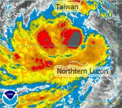
NAGA CITY (Aug 28, 2011 12:30 P.M.) - Typhoon Mina (International name: Nanmadol) has already killed 6 in the Philippines and now takes aim at Taiwan. Its core has started to move away from the Batanes Group as it moves directly northward towards Southern Taiwan at 15 kilometers per hour (kph).
Mina has weakened into a Category 2 storm with wind velocity of 165 kph (90 kts) near the center and gusts up to 205 kph.
Residents of Batanes Islands still experience typhoon conditions but Mina's fury is expected to recede later today. Its inner rainbands now cover Ilocos Norte, Northern Cagayan, Bashi Channel and the Southern Coast of Taiwan.
This typhoon will continue to enhance the Southwest Monsoonal Flow across Western Luzon, bringing passing occasional rains with strong winds.
At 12 noon today, the eye of Mina was located 56 kilometers West of Itbayat, Batanes or 140 kilometers South of Orchids Island, Taiwan at coordinates 20.8º North Latitude 121.3º East Longitude.
Rainfall accumulate is estimated at heavy 30 mm/hour.
Typhoon Mina is expected to turn North-Northwest in the next 24 to 36 hours and may still re-intensify a little before making landfall over Southern Taiwan.
On the forecast track, the core of the Typhoon Mina will approach the shores of Southern Taiwan tomorrow morning (Monday) and cross the mountainous terrain of Southern Taiwan late Monday morning until the evening. It shall then weaken into a Tropical Storm (TS) as it bends Northwestward into Taiwan Strait.