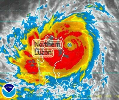
Super Typhoon Mina poses danger to Cagayan, Batanes

NAGA CITY (Aug 26, 2011 11:00 P.M.) - Mina is now a Super Typhoon and it poses danger to Cagayan and Batanes as it packs a center wind of 250 kilometers per hour (kph), breaching Category 5 level, and its inner rainbands bring heavy squalls along Cagayan, Isabela and Northern Aurora. Peak wind gusts near the center reach 305 kph.
Mina's movement is rather slow at 9 kph towards the general direction of Cagayan and Batanes.
As of 6 P.M. tonight, Mina's center was located 91 kilometers East-Northeast of Palanan Bay, Isabels or 193 kilometers Northeast of Casiguran, Aurora at coordinates 17.5º North Latitude 123.3º East Longitude.
The Philippine Atmospheric, Geophysical and Astronomical Services Administration (PAGASA) has raised Typhoon Signal No. 4 over Cagayan.
Signal No. 3 is raised over Isabela, Rest of Cagayan, Calayan, Babuyan Group of Island and Batanes Group of Island while Signal No. 2 is up over Northern Aurora, Quirino, Ifugao, Mt. Province, Kalinga and Apayao.
Signal No. 1 is up over Nueva Vizcaya, Benguet, Ilocos Sur, Ilocos Norte, Abra and the rest of Aurora.
Aside from the typhoon strength winds, residents in low-lying and mountainous areas under Public Storm Warning Signals, including in Southern Luzon and Visayas are advised to prepare for possible flash floods and landslides.
Mina covers a diameter of 665 kilometers and its 24-hour Rainfall Accumulation near the center is projected at a very high 510 mm. Furthermore, Mina enhances the southwest monsoon and areas as far as Southern Luzon, Western sections of Central Luzon, Visayas and Mindanao may experience widespread rains that can trigger flash floods and landslides.
Residents of Taiwan, Okinawa & Southern Japan have been alerted of possible adverse effects of Super Typhoon Mina.
While not expected to make a landfall, Mina shall pass very close to Cagayan's Northeast coast Saturday morning, 110 kilometers East-Northeast of Aparri, while packing a center wind close to 260 kph.
Mina's closest approach to Batanes occurs Sunday morning, 33 kilometers East of Basco, when Mina's strength is projected to be 270 kph.
Winds up to 118 kph extend outward from Mina's center and areas up to 270 kilometers further out can experience winds up to 62 to 117 kph.